
Could someone re-upload these two files? I am only able to download the text-searchable version from this site:
http://doomzdaypreppers.com/wp-content/ ... es.pdf.pdf
"Caves of Missouri" (Bretz) - RARE - download link
-
fordtrucknut
- 0-99 Poster

- Posts: 1
- Joined: Mon Jul 15, 2013 9:08 pm
RE: "Caves of Missouri" (Bretz) - RARE - download
hello found this site while looking for another version of this book, one thing I can not figure out is the coordinates they are using? sorry if i sound dumb, just getting into caves and things, and a few of them might be within a few miles of me, but lost to the times, because no info can be found on them except this book.
Re: RE: "Caves of Missouri" (Bretz) - RARE - downl
Approach your county's assessor. He/she ought to help you understand how to read it. It'll be a hell of a lot of work, believe me.fordtrucknut wrote:hello found this site while looking for another version of this book, one thing I can not figure out is the coordinates they are using? sorry if i sound dumb, just getting into caves and things, and a few of them might be within a few miles of me, but lost to the times, because no info can be found on them except this book.

RE: "Caves of Missouri" (Bretz) - RARE - download
So none knows what kind of coordinates these are?

Re: "Caves of Missouri" (Bretz) - RARE - download
If he said to approach the Assessor then they are most likily Township, Range, Section, Quarter-Section, and Quarter Quarter-Section. But I don't know that for sure since I didn't bother to look.
But if it's something like, "NW of the NE of Sec 6 T23 R16," then that is what it is. And if you look at a County Assessor's map which are laid out by township and range you can get pretty close to the mark. A section is a square mile. A quarter section is a square 1/4 mile and a quarter quarter section is a square 1/16 mile.
Google the PLSS, the Public Land Survey System.
Also: They don't always use the quarter quarter section, sometimes just the quarter section.
More online investigation than onsite exploration these days.
“My dear fellow, who will let you?”
“That’s not the point. The point is, who will stop me?”
-Ayn Rand
“My dear fellow, who will let you?”
“That’s not the point. The point is, who will stop me?”
-Ayn Rand
RE: "Caves of Missouri" (Bretz) - RARE - download
Thanks nicotti. 
Re: "Caves of Missouri" (Bretz) - RARE - download
http://tacnet.missouri.org/~mgood/Mapso ... -ByID.html
^Here is a good site of old maps of mo like he references in the book (quadrangle maps)
The county websites are good as well. just sharing info
^Here is a good site of old maps of mo like he references in the book (quadrangle maps)
The county websites are good as well. just sharing info
Btw I'm a douche. That is all...
-
PANIC! on the Titanic
- Titanic Penis

- Posts: 1806
- Joined: Sun Feb 01, 2009 10:39 pm
- Location: I am everywhere and nowhere, especially in Missouri
Re: "Caves of Missouri" (Bretz) - RARE - download
USGS has free topos available for the entire US coverage, and you can pick from various years on the location you select from the map. 15 minute quads are generally too big to be of much use when it comes to pinpointing with any precision, but are still cool to look at and tend to be older. Bretz never references 15' quads in his book.
Also note that topos after the early 70's won't show you near as many caves, as the private landowners largely requested cave location be removed due to people trespassing and vandalizing. So, USGS obliged and removed most caves from the maps.
And just to be clear, topo coords like NW 1/4 SW 1/4 S.6 T.22N R.7W would read "northwest quadrant of the southwest quadrant of section 6 in township 22 north in range 7 west.
Read it backwards when you have the topo in front of you. Township numbers are found on the sides of the map, Range numbers on bottom and top and each have a thicker red line. Sections are the red numbered squares gridding the map. divide those squares into quadrants, NE, NW, SE, SW. then if you have to, take one of those quadrants and divide THAT into quadrants. That should do it. It's not hard, just gotta do it once or twice. Now you know how to read a topo map.
Re: "Caves of Missouri" (Bretz) - RARE - download
http://digital.library.umsystem.edu/cgi ... ge;seq=356
So when he writs here about mystery cave saying it is not located on the quadrangle map but gives coords you r saying I can't use that map to find the cave?
So when he writs here about mystery cave saying it is not located on the quadrangle map but gives coords you r saying I can't use that map to find the cave?
-
PANIC! on the Titanic
- Titanic Penis
- Posts: 1806
- Joined: Sun Feb 01, 2009 10:39 pm
- Location: I am everywhere and nowhere, especially in Missouri
Re: "Caves of Missouri" (Bretz) - RARE - download
No, what he's saying is that mystery cave doesn't have a cave symbol and a label on the topo, but that's where it is.
There are several reasons why it wouldn't be labelled:
- The topo for that area was created before the discovery of the cave (can't map what you don't know exists)
- The private landowner requested it not be shown on the map
- Not a significant enough landmark to make it to the map (unlikely, as smaller caves have made it to topos)
- The area wasn't field checked by cartographers and thus nobody making the maps knew there was a cave there
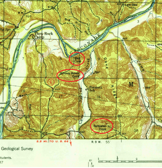
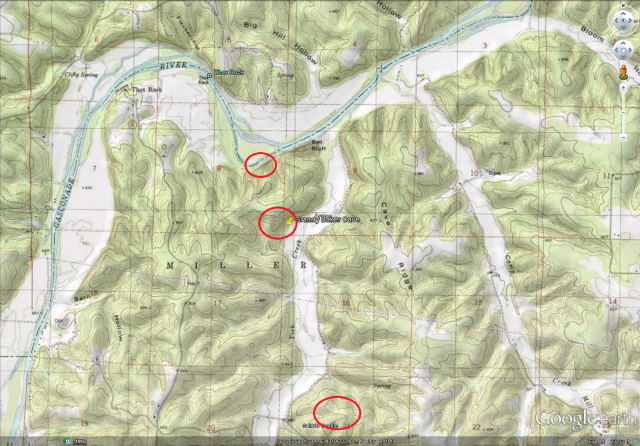
Check this. first image is of a 1949 topo, showing 3 caves in an area. The next map made of the area (image 2) is the topo made in 1980, and the caves disappeared. They are still there, just 'Not Shown" though they would have been shown on any maps Bretz had, which would have been the 1949 topo.
There are several reasons why it wouldn't be labelled:
- The topo for that area was created before the discovery of the cave (can't map what you don't know exists)
- The private landowner requested it not be shown on the map
- Not a significant enough landmark to make it to the map (unlikely, as smaller caves have made it to topos)
- The area wasn't field checked by cartographers and thus nobody making the maps knew there was a cave there
Check this. first image is of a 1949 topo, showing 3 caves in an area. The next map made of the area (image 2) is the topo made in 1980, and the caves disappeared. They are still there, just 'Not Shown" though they would have been shown on any maps Bretz had, which would have been the 1949 topo.
Re: "Caves of Missouri" (Bretz) - RARE - download
Can u pm me a link to that first old map
Btw I'm a douche. That is all...
Re: "Caves of Missouri" (Bretz) - RARE - download
On the odd chance the sections aren't numbered. Section 1 is the northeast most square. Then they count west up to 6 then 7 is below 6 and they count up to 12 (below 1 above 13). If the township & range is complete (as opposed to being cut off by a large body of water or something) there should be 36 sections.PANIC! on the Titanic wrote:Sections are the red numbered squares gridding the map.

More online investigation than onsite exploration these days.
“My dear fellow, who will let you?”
“That’s not the point. The point is, who will stop me?”
-Ayn Rand
“My dear fellow, who will let you?”
“That’s not the point. The point is, who will stop me?”
-Ayn Rand
-
PANIC! on the Titanic
- Titanic Penis
- Posts: 1806
- Joined: Sun Feb 01, 2009 10:39 pm
- Location: I am everywhere and nowhere, especially in Missouri
Re: "Caves of Missouri" (Bretz) - RARE - download
Why they gotta do things so backwards? Damn arabs, making us read our topo sections right to left.
Re: "Caves of Missouri" (Bretz) - RARE - download
Only every other row though...
More online investigation than onsite exploration these days.
“My dear fellow, who will let you?”
“That’s not the point. The point is, who will stop me?”
-Ayn Rand
“My dear fellow, who will let you?”
“That’s not the point. The point is, who will stop me?”
-Ayn Rand